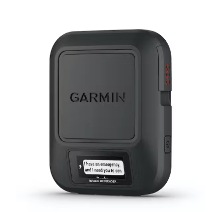
Garmin GPSMAP 67i + inReach
FREE GIFT ORDER $150+
Garmin GPSMAP 67i + inReach
Handheld Satellite Communicator with GPS Navigation
Merging the navigation power of the GPSMAP 67 with the communication and PLB functionality of an inReach, the 67i will keep you confident and connected. The Iridium satellite network lets you send and receive text messages and emails anywhere on the planet (subscription required).
Each message contains your GPS location data, so followers can track your adventures. If things take a turn for the worse, a dedicated SOS button means that help is never out of range.
Enhanced messaging functionality comes when paired with the free Garmin Messenger app you can use your phone to send and receive detailed messages. Great for setting up a group chat to keep family and friends up to date on your adventures.
With access to 5 different satellite networks, class leading battery life, free topographical maps, and satellite imagery, the 67i helps smooth out bumps in backcountry navigation. Multiband GNSS technology gives the 67i more satellites and more signals to choose from, so you get fast and accurate positioning data, all over the globe.
The free Garmin Explore™ app lets you plan trips on your computer, tablet, or phone. Once you're ready to start, send planned routes and tracks to your 67i, no cell network required, and it won’t cost you a thing.
Features:
- Preloaded with routable TopoActive maps (Canada and US 100K resolution), featuring streets and trails
-
Multiband and multifrequency signal reception and expanded GNSS support (GPS, GLONASS, Galileo, QZSS and IRNSS) has access to more satellites and more signals, this provides faster, more accurate positioning and elevation data, anywhere in the world
-
Point of interest navigation lets you search for places you may want to go, e.g., restaurants, attractions, accommodation, etc
-
Connects via Bluetooth to phones/tablets running the free inReach Messenger® app. When paired with the Messenger app you gain access to your phone’s keyboard, contacts and group text capabilities
-
Smart network switching technology sends and receives your messages via the most reliable available network, helping ensure your messages get though, and you only use your satellite subscription when you need it
-
Messages have your GPS location embedded, letting your rescuers, friends, family or followers know exactly where you are
-
GPS tracking feature allows your friends and community to follow your progress via a personalized MapShare® page
-
LiveTrack™ during activities (through a connected smartphone) shares your location with friends
-
GroupTrack displays the location and telemetry of up to 50 contacts with compatible Garmin devices
-
Active weather provides real-time radar tracking (via a connected phone running Garmin Connect)
-
World coverage SOS feature gives you a confirmation message from the International Emergency Response Coordination Center (IERCC) if you use it to send an SOS. 2-way texting allows you to stay in contact with rescue personnel
-
SOS messages are received by IERCC, a worldwide emergency response coordination center with 24/7/365 staffing
-
SOS button has a hard plastic cover, greatly reducing chances of an accidental activation
-
Uses Iridium’s constellation of 66 satellites for coverage of the earth's entire surface. Messages are buffered for up to a day
-
Iridium’s worldwide coverage lets you send texts and emails from anywhere in the world. Your plan determines how many you can send and how detailed they are. Note – some jurisdictions regulate or prohibit the use of satellite communication devices
-
SOS/PLB functionality and all off-grid communication requires a separate satellite plan to activate, GPS functionality works all the time, no plan required
-
Monthly plans are available, as well as seasonal hibernation options that allow you to pay a minimal fee during months when you are not using the device
-
Garmin Explore website and app let you sync routes, tracks and waypoints to your device. You can download map data to your phone, use your phone to plan routes and tracks, and then send those plans to your GPS, all without cell reception
-
Satellite caching saves an extended predicted orbit path (EPO) file, so it knows where to look for satellites when you turn it on
-
Barometric altimeter tracks ascents, descents and total elevation changes
-
Tilt-compensated 3-axis electronic compass shows your heading even when you're stationary
-
Extended battery life, with multiple different GPS modes let you find the perfect balance of battery life and GPS accuracy
-
Internal Lithium-ion rechargeable battery provides up to 165 hours of battery life in GPS mode and more than 2 weeks in inReach enabled Expedition mode
-
3in. colour screen is bright and clear even direct sun
-
16GB internal memory can be increased via MicroSD cards (not included)
-
IPX7 waterproofing
-
Built-in LED flashlight has S.O.S setting
Included in the Box:
- GPSMAP 67i preloaded with 100K TOPO Canada and US maps,
- USB cable (A-C)
- Carabiner clip
- Instructions